Modern European
The next great revolution in navigation occurred in the
20th Century, when radio signals came into wide use. The development of radar, loran (long range navigation), and radio direction finding during World War II caused
fundamental changes in navigational practice; a mariner or pilot today can turn
on a Loran or Global Positioning System receiver and determine position and
course to within a few yards. Inertial guidance systems, most often used to
navigate submarines, aircraft, and spacecraft, allow navigation without contact
with a ground base. In such systems, a computer navigates the vehicle with the
aid of an inertial navigator device, which consists of a gyroscope to indicate
direction and an accelerometer to measure changes in speed and direction.
Inertial guidance systems and terrain-following radar allow a cruise missile to
fly a thousand miles and hit its designated target. The development of
navigation satellites beginning in the 1960s led in the 1990s to the U.S.'s
Global Positioning System (GPS), which provides location and other information
through the reception and interpretation of signals received from satellites;
Russia and China have since created similar navigation systems. GPS receivers,
which are now incorporated into smartphones and other devices, have made it
possible to create navigation systems for vehicles and other forms of
transportation.
LORAN
(LOng RAnge Navigation) A ground-based navigation system developed by the U.S. government during World War II. Modeled after the British GEE system, LORAN receivers pinpoint their location by triangulation with three LORAN transmitters, approximately 75 of which are located throughout the world. With 29 ground stations covering all of North America, LORAN's long-range signals provide an economical navigation system, although less precise than GPS with its correction systems.
LORAN-C
LORAN-C is the surviving LORAN technology. Developed with great haste during World War II, LORAN-A was still used during the Vietnam war for aircraft navigation. LORAN-B was an improved version, which was abandoned in favor of LORAN-C.
LORAN-D modified LORAN-C for short-range use, and LORAN-F was an alternate name for a Motorola navigation system for unmanned drones.
eLORAN
After China shot down its own communications satellite in 2007, there was renewed interest in LORAN as backup to the satellite-based GPS system, should it ever be compromised. eLORAN (an Enhanced LORAN) uses more advanced receivers and transmission modes, which improves LORAN accuracy to eight meters. eLORAN receivers accept all signals within range as well as a new set of correction signals.
PC Magazine Encyclopedia
RADAR
Radar is a machine that uses radio waves for echolocation to find
objects such as aircraft, ships and rain.
The basic parts of a radar are:
The transmitter creates the
radio waves.
The antenna directs the radio
waves.
The receiver measures the waves which are bounced back by the object.
By doing this, the radar can locate the
object. Radar is used in many different ways. It can measure the speed and
number of cars on a road, the amount of water in the air, and many other
things.
Radar was first used in 1904 by Christian Hulsmeyer for which he was given a patent. It became commonplace
during World War II.
The word RADAR was created in
1942 as an acronym for Radio Detection and Ranging. This acronym
replaced the British initials RDF (Radio Direction Finding).
Radar ranges and bearings can be very
useful navigation. When a vessel is within radar range of land or special radar
aids to navigation, the navigator can take distances and angular bearings to
charted objects and use these to establish arcs of position and lines of
position on a chart. A fix consisting of only radar information is called a
radar fix.
Another special technique, known as the
Franklin Continuous Radar Plot Technique, involves drawing the path a radar
object should follow on the radar display if the ship stays on its planned
course. During the transit, the navigator can check that the ship is on track
by checking that the pip lies on the drawn line.
Display and control unit of a common
maritime navigation and search radar.
Global Positioning System
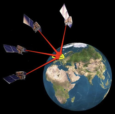
The Global Positioning System
(GPS) is a constellation of 27 Earth-orbiting satellites (24 in
operation and three extras in case one fails). The U.S. military developed and
implemented this satellite network as a military navigation system, but soon
opened it up to everybody else.
Each of these 3,000- to 4,000-pound
solar-powered satellites circles the globe at about 12,000 miles (19,300 km),
making two complete rotations every day. The orbits are arranged so that at any
time, anywhere on Earth, there are at least four satellites “visible” in the
sky.
A GPS receiver “knows” the location of
the satellites, because that information is included in satellite
transmissions. By estimating how far away a satellite is, the receiver also
“knows” it is located somewhere on the surface of an imaginary sphere centered
at the satellite. It then determines the sizes of several spheres, one for each
satellite. The receiver is located where these spheres intersect. The accuracy
of a position determined with GPS depends on the type of receiver. Most
hand-held GPS units have about 10-20 meter accuracy. Other types of receivers
use a method called Differential GPS (DGPS) to obtain much higher accuracy.
DGPS requires an additional receiver fixed at a known location nearby.
Observations made by the stationary receiver are used to correct positions
recorded by the roving units, producing an accuracy greater than 1 meter.
GPS is exclusively operated and
controlled by USA. China is developing its own navigation system COMPASS.
European Union is developing GLONASS.
The Global Positioning System


No comments:
Post a Comment